 Mijn Studiezaal (inloggen)
Topografische Kaarten
1 records
620 Topografische Kaarten
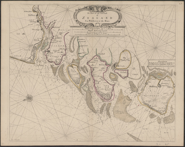

TA_RIV_025 A Chart of the Sea-coast of Zealand From Walcheren to the Maes, 1675.
Datering:
1675
Titel:
A Chart of the Sea-coast of Zealand From Walcheren to the Maes
Beschrijving:
Zeekaart uit: Atlas Maritimus or the Sea Atlas
Vervaardiger:
John Seller, hydrographer to the King
Opmerkingen:
De kustzone heeft diepte aanduidingen
Adres:
Brielle,
Datum:
1675
Collectie:
Streekarchief Voorne-Putten
Schaal:
met vermelding meetschalen; Engish and French leagues 20 degree, Duytsche Mylen 15 en een graad, Leagues de Spania 17,5 Grada
Afmeting:
57 x 45 cm
Kleur:
kleur
Locatie:
F008
Uitgever:
John Seller, hydrographer to the King
laatste wijziging 02-08-2021
1 gedigitaliseerd